

asfa
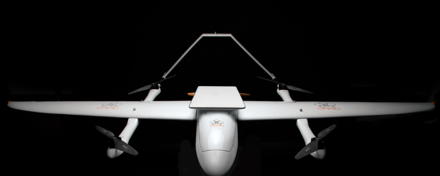
orkid 260vtol
Mapping drone Variant
Precision Mapping Redefined with the ORKID 260VTOL Drone

001 – orkid 260 vtol – mapping Variant
( XXX )
The ORKID 260VTOL Mapping Drone Variant offers a versatile and high-performance solution for aerial mapping, available in two configurations to suit diverse needs. Our high-end variant utilizes the state-of-the-art Phase One P5 system, delivering unparalleled detail and accuracy, while our more accessible option features the Sony ILX-LR1 for cost-effective, reliable mapping. Both configurations ensure exceptional data capture, making ORKID the ideal choice for precision-driven geospatial applications.
Unmatched
Precision and
Coverage for Every
Mapping drone mission
ORKID 260VTOL Mapping Drone Variant
Delivering high-resolution data accuracy for applications in surveying, agriculture, urban planning, and more with the ORKID 260VTOL Mapping Drone.
4.3
mm
GSD
55
m
SWATH AREA
80
mm
PIXEL BLUR
80
mm
FOCAL LENGTH
21
m/s
AIRSPEED
a01
HIGH-PRECISION PAYLOADS SUBHEADING
Equipped with cutting-edge cameras like the Phase One P5 system, the ORKID Mapping Drone delivers unmatched GSD and swath area accuracy.
a02
OPTIMIZED FOR EFFICIENCY
Achieves 60 minutes of flight endurance and operates at 21 m/s, ensuring fast and reliable data capture for mapping drone missions.

a03
SEAMLESS AUTONOMY
Powered by intelligent cloud-based mission planning, the ORKID Mapping Drone enables fully autonomous mapping operations with unmatched precision.

a04
FLEXIBLE ARCHITECTURE
Designed to integrate advanced mapping payloads effortlessly, delivering unmatched versatility for diverse mapping drone applications.
Eyes in the Sky, Precision on the Ground
Empowering real-time intelligence with advanced optics for Cost-Effective Mapping Drone Missions
[01]
Two Options, One Standard of Excellence
Choose between the Phase One P5 system with 4.31mm GSD, 55m swath area, and minimal pixel blur, or the Sony ILX-LR1 for dependable mapping performance at an affordable price
[02]
Wide Area Coverage, High Detail
Capture extensive swath areas with precision, ensuring accurate, detailed data across large landscapes
[03]
Optimized for Speed and Stability
Designed for smooth, stable operations at 21 m/s and 100 meters AGL, ensuring optimal performance for high-speed mapping
[04]
Intelligent Mission Planning and Autonomy
Autonomous flight with cloud-based mission planning for seamless, efficient mapping operations

/003
Tech Specs
Tech
Specifica–
Tions
Tech SpecificaTions
ORKID 260VTOL
— mapping Variant
001
Max Speed
80 km/h (22 m/s)

002
Optimal Mapping Speed
21 m/s
003
Max Flight Time
60 minutes (with mapping payload)
004
Operational Range
80 km (BVLOS enabled)
005
Max Wind Resistance
12 m/s (Operational)
B00
High-End Option
B01
Camera
Phase One P5 System
B02
Ground Sampling Distance (GSD)
4.31mm
B03
Swath Area
55 meters
B04
Pixel Blur
0.73 (at 100m AGL, 21 m/s)
B00
Low-End Option
C01
Camera
Sony ILX-LR1
C02
Resolution
Cost-effective and reliable performance for entry-level mapping missions.
b01
C2 Link
Full Satellite Integration (Starlink) – no ground infrastructure required, offering centralized, autonomous operations worldwide.


b02
Mission Planning
ORKID’s intelligent cloud platform ensures seamless mission planning, data collection, and analysis.

b03
Autonomy and Flexibility
Modular payload support with MAVLink-enabled functionality for easy integration and deployment.

/004
Geomapping solution
Setting new standards for geospatial data in agriculture, urban planning, and infrastructure
( 004 )
Elevating Drone Mapping Across Critical Applications
The ORKID 260VTOL Mapping Variant is revolutionizing geospatial data collection and interpretation with tailored solutions to meet diverse project needs. The advanced Phase One P5 system delivers unparalleled precision, offering a 4.31mm GSD, a 55-meter swath area, and minimal pixel blur, making it ideal for projects requiring the highest data fidelity. For cost-sensitive applications, the Sony ILX-LR1 configuration ensures dependable mapping drone performance, combining reliability with affordability without compromising quality.
Whether for surveying, agriculture, environmental monitoring, or urban planning, ORKID’s Mapping Variant delivers the flexibility, accuracy, and efficiency to empower impactful geospatial decisions.
Ready to elevate your mapping capabilities, structure, enhancing public safety, or supporting military operations, ORKID delivers unmatched capability and efficiency.
/005
Get in touch
ready to elevate your operations?
(contact)
